


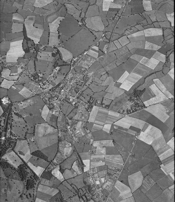
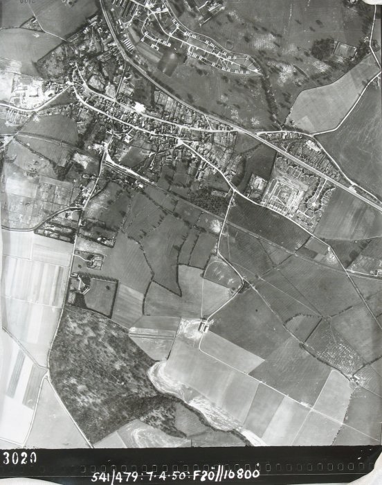
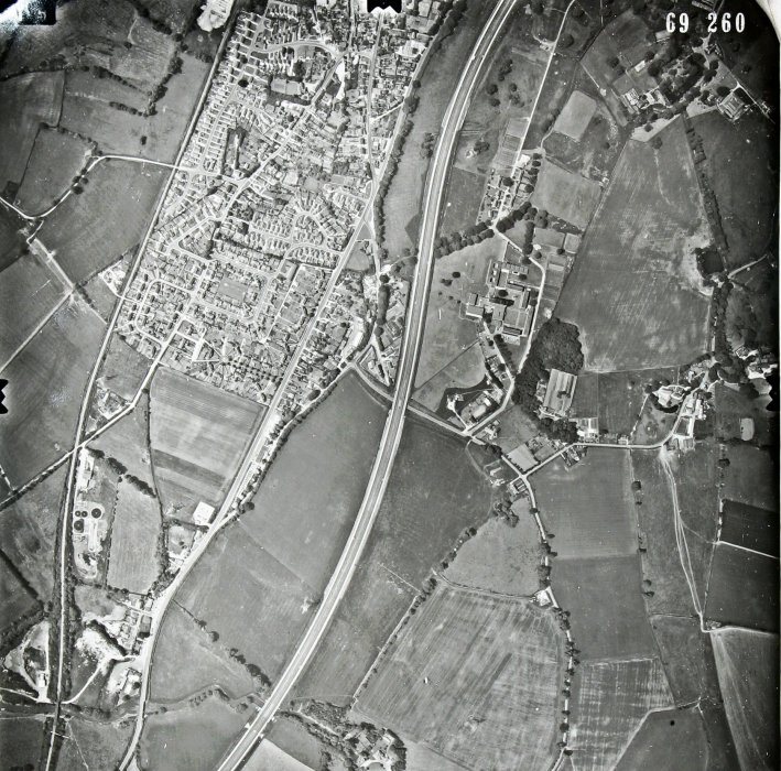
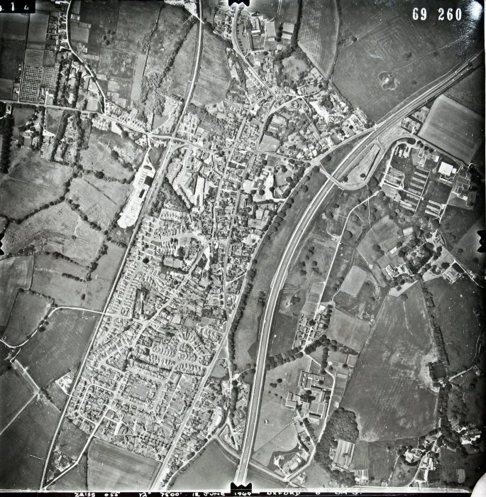
1944, 1950, 1954,1969 (2 versions) Aerial maps

Archive Notes:
1944, 1950, 1954, 1969 (2 versions) aerial maps, acquired from Historic England in 2018 with permission to use, 1954 map is reference raf_82_1006_f61_0309
Related Items:
- Bricks
- Mary Andrews' will
- Ann Bentlee's property
- Abraham Archdale's will, 1631
- Richard Archdale's will 1577
- Thomas Dormer's will, 1543
- Inventlory of Elin House's property, 1592
- George Martin's will, 1614
- Sibble Moore's will and inventory
- John Mount's will and inventory 1556
- Thomas Mount's will and inventory
- Thomas Mount of Wheatley, will and inventory
- Mary Russel's will, 1705
- Inventory of Marie Spencer's property, 1621
- Will of Thomas Temple, 1691
- Elizabeth Temple's will, 1698
- William Smart's will and property, 1670
- Thomas Whorwood III's will, 1736
- Edmund Whorwood's will 1735
- Jane Whorwood's will, 1715
- Thomas Whorwood II's will 1706
- Other wills
- Poor quality photos of Inns
- Oxfordshire Licensed Victuallers 1822
- Licensees 1684-1911
- Wheatley's roads
- Road maps
- A40 from Oxford to Wheatley
- 19th century coaching
- Account of highwaymen
- Shotover Hill and Turnpike
- Wheatley Bridge and ford
- 1930 roadworks
- Wheatley By-pass
- Meals On Wheels in Wheatley
- The Great Blizzard 1962
- History unfolded at Wheatley (1970)
- Families fear lives at risk
- Wheatley Society Exhibition, 1978, of clothes c.1900
- Wheatley Parish Council Elections 1979
- Newspaper cutting of A40 flyover
- Bypass newspaper account
- News reports and photo relating to A40 and M40
- Submission to public inquiry re M40
- Repairs to A40
- News reports regarding main roads
- Ground plans, M40 Wheatley services + recruiting
- Photos of newly-opened Wheatley services, 1998
- Demands for 20mph limit on Wheatley roads
- Milestones and Drove Roads in Oxfordshire
- Wheat Aid - 1991
- Wheatley Parish Council Elections 1983
- Wheatley Parish Council Elections 1987
- Wheat Aid 1991
- Morris tunes and songs
- Wheat Aid 1991
- Pharmacy opens in Wheatley 1993
- Roman & Saxon Wheatley 1984
- Rabbit Warren
- Revival of Wheatley Morris Dancers
- Origins of the Archive Room 2002
- Wheatley Post Office 2003
- Plastow's Travel 2003
- Handlist of Plans for Railways in Oxfordshire
- Directories of occupations
- Bennett's Business Directory 1904
- Bobbin making for trawlers
- Wheatley limestone
- Holton Stone Pit
- Ochre in Wheatley
- Brickmaking
- Horse-drawn harvesting machine
- List of schools from 1818
- Schools Old and New with list of heads
- Modern Citizenship
- A Trip to visit 'The Bremen' 1938
- Lark Rise to Lark Rise
- Wheatley Records 956-1956
- One More Millennium: Story of Wheatley and Holton
- Centenary of The Merry Bells 1888 -1988
- Holton, Wheatley and Oxford in the Civil War
- Around Wheatley
- Margaret Axford booklet on Tales from the Village Folk
- Wheatley Celebrates 1977
- Tanning Barn to Church
- 3 'R's by Candle light
- Sale notice for arable land at Wheatley
- Aerial photograph of Wheatley
- Panorame of Wheatley and photo of Wheatley High St, C 1930
- Sepia photo looking west up Wheatley High St
- 'Picture of Wheatley, Oxfordshire'
- Panoramic view of Wheatley, c. 1920
- Church Road / London Road link
- Blenheim, Kiln Lane & Westfield Roads
- View of Blenheim from Parish Plan 2004
- Farm Close Road and Beech Road
- Farm Close Road
- Ladder Hill
- Wheatley from Ladder Hill
- Mill View Garden centre entrance in 1988
- Map of Wheatley and Holton hospital
- East end of London Road in 1987
- London Road views from Wheatley bridge 1987
- London Road - Wheatley Bridge
- London Road photos 1979 - WVA only
- London Road 2004
- London Road from the Plough in 1987
- Wheatley Brook
- Old London Road
- Oxford to London road reconstruction
- Milestone in London Road
- London Road Kings Arms Turn
- London Road and Holton Park wall
- London Road from Holloway Road junction 1987
- London Road / Holloway - 1976
- London Road / Holloway circa 1930
- The Queen in Wheatley
- Views from Farm Close Lane in 1989
- North view from Farm Close Lane in 1975
- Steam Roller at the Holton Fair in 1970
- Farming - Wilfrid Sheldon's recollections
- Footpath Crown Road to Ambrose Rise 2004
- Wheatley's connection to Cuddesdon
- Memorial to Rev. Purson who died in 1903
- Articles of inquiry from 1759
- Jacket P1/A1a
- Skirt P1/A1b
- Dress P1/A2
- Dress P1/A3
- Skirt P1/A4
- Jacket P1/A5
- Skirt P1/A6
- Skirt P1/A7
- Navy flannel skirt P1/A8
- Black textured skirt P1/A9
- Gold lace blouse P1/A10
- Cream skirt P1/A12
- Pink underskirt P1/A13
- Skirt petticoat P1/A14
- Knickers P1/A15
- Stockings P1/A16
- Stockings P1/A17
- Mittens P1/A18
- Collar / brooch P1/A19
- Headcovering P1/A20
- Underskirt P1/A21
- Underskirt P1/A22
- Blouse P1/A11
- Aprons P1/A23 a,b,c,d
- Apron P1/A24
- Pinafore P1/A25
- Nightdress P1/A26
- Bonnet P1/A27
- Nurse's uniform P1/A28
- Nightgown P1/A29
- Coat and bonnet P1/A30 a & b
- Valance P1/A31 a,b,c
- Cushion cover P1/A32
- Nightdress case P1/A33
- Tray Cloth P1/A34
- Fur muff P1/A35
- Lace P1/A36
- 1-17 Bell Lane
- Notice re polluting of stream
- Extracts from Rev. Elton's diaries
- St Birinus Pilgrimage
- Edward Elton's appointment in 1849 and diary extracts
- Phoenix Assurance Firemark
- High Street - Traffic Calming
- New housing developments in Wheatley 1929-1987
- 1892 Royal commision on Labour ref Wheatley
- High Street, The London to Oxford Road
- Littleworth hamlet per Victoria County History
- Jane Whorwood
- Cromwell Cup
- High Street residents 1900 - WVA only
- Wheatley Military Hospital
- Forest Hill with Shotover book 1933 - WVA only
- Floods around Wheatley in 1992
- Road Names
- Wheatley area Churches
- Wheatley tortoises for Trinity College
- Notice found on URC wall
- Cuddesdon College centenary 1854-1954
- Littleworth and the windmill
- Collection of funeral and other cards
- Request for home nursing sheet
- Sheets of school work - WVA only
- Harris family letter - WVA only
- Harris family letter - WVA only
- Harris family letter - WVA only
- Harris family letter - WVA only
- Harris family letter - WVA only
- Harris family letter - WVA only
- Harris family letter - WVA only
- Harris family letter - WVA only
- Harris family letter - WVA only
- Harris family letter - WVA only
- Harris family letter - WVA only
- Harris family letter - WVA only
- Harris family letter - WVA only
- Harris family letter - WVA only
- Harris family letter - WVA only
- Harris family letter - WVA only
- Harris family letter - WVA only
- Harris family letter - WVA only
- Harris family letter - WVA only
- Harris family letter - WVA only
- Original Invoice from Harris Stores - WVA only
- Notes on property not relevant to Wheatley - WVA only
- A W Gamage Invoice - WVA only
- Various invoices - WVA only
- Invoice
- Solicitor's correspondence
- Post Office Telegram - original
- Letters written by Gilbert
- Letter written by Henry Harris
- Receipts of rental payments
- Letters from British Drug Houses 1917 - WVA only
- Order from British Drug Houses - WVA only
- Letters from British Drug Houses Ltd 1918 - WVA only
- The Kingerlee Institute
- Letter from Borough of Chipping Norton
- National League of Young Liberals
- South Oxfordshire Liberal Association
- Thank you letter to Mrs Harris 1926 - WVA only
- Letters from Bateman 1927 - WVA only
- Letters to Mr Harris - WVA only
- Housing developments in the twentieth century
- Victoria County History of Wheatley
- Aerial photographs of Wheatley and Holton
- Aerial photograph May 1961
- Aerial photograph of centre of Wheatley 1961
- Aerial photograph Coombe Wood and surrounding 1981
- Aerial photograph Castle Hill Farm and Roman Road 1981
- Aerial photograph Cuddesdon Road junction
- 11 Aerial photographs taken in 1994
- 4-5 mile walk around Wheatley described
- General views of Wheatley 2002 and 2018
- Postcard with five views of Wheatley
- Post card with five views of Wheatley
- Booklet of eight views of Wheatley c.1950
- Wheatley in the mid 70's
- Aerial view of Wheatley in 1952
- Saxon Graves on Castle Hill
- The Hinton Collection of early postcards of Wheatley - 1913-1915
- Winter snow 1991
- Firemark
- Stone hot water bottle
- 2 horse shoes
- Spar cutting hooks
- Stone water bottle
- Hook and bolt
- Thatching shears
- Stone water bottle
- Stone water bottle with cork
- Ostermilk tin
- Pattens
- Bit piece
- Sample of Ironstone
- Alleyway between Westfield Road and Park Hill
- Snow scenes January 1982
- Vaccination Register
- Fred Anson's Memorial Service
- Ministers who served in Cuddesdon & Wheatley
- The Changing Face of Wheatley
- WW1 swagger stick
- Four aerial views of Wheatley in 2007
- Litter Blitz 2004
- Letter from Brigadier General Alfred Douglas Miller
- Holton Church
- Military Hospital at Holton Park
- Holton Park Military Hospital
- Military Hospital
- Hammerstone
- Wheatley Flood 2008
- Edward Elton's appointment
- Footpath from Station Road to Farm Close Road
- Milk Delivery in Wheatley
- Local Views 1965
- Mary Sturch's collection of clothing c.1880-1917
- The Idler: a paper published at The Old Crown
- Meet of South Oxfordshire Hunt 1965
- Fifteen coins dating from 1771- 1873
- Oxford Journal 1760 - 1850
- Cattle bell
- Child's walking cane
- Cow bell
- 'The King's Smuggler' by John Fox
- Postcard of Wheatley taken from The Howe 1907
- Houses for Sale Summer 2010
- Sword found on Shotover
- Wartime account of Canadian allies running amok
- Wheatley Friendly Societies 1825 -1862
- Wheatley Charities
- Ironwork from the forge
- Traffic in the High Street July 2011
- Clay tiles
- Accounts of Village Organisations 1891
- Information about sale of Manor Farm 21/02/1846
- Cornfield Bakery
- A40 road noise
- Wheatley Park School 'failing'
- 'Rare bumblebee'
- Murder of Debbie Smith 2008
- Roland Yeates drugs dealer
- Jon Shirley
- SODC wants Wheatley to be removed from Green Belt
- Local History competition 1980
- O.S. maps (edition 1921)
- O.S. maps (edition 1974)
- Map of Wheatley district 'fieldnames'
- Two maps of Wheatley area 1980
- OS maps 1: 2500 Pathfinder Series 1980
- OS map 1880
- 4 copies of 1921 O.S. MAPS 1:2500
- O.S map Oxfordshire XXXIV SW ( 6 in. mile) 1938
- Christening gown
- Evening dress and accessories
- Wheatley District Conservative Assn
- Village Produce Association
- O.S. MAPS Wheatley area c.1960
- Road Map c. 1948
- O.S. MAP 1881
- O.S. Maps, 1921/22 1:2500
- O.S. Maps 1938 1:2500
- Black Lace Collar
- Horspath Reservoir
- Oxford Brookes University
- Mr Huxter's carriage in High Street
- Heritage trail around Wheatley by Pullen 1939-1955
- Historical Wheatley Map based on map from 1590s
- Home Guard
- OS map revised 1897-8
- Unexploded bomb in Wheatley
- Wheatley - a Snapshot of 3 centuries - Feb 2013
- Extracts from Directories up to 1939
- Iron Fire Surround (part), clay pipes & fossils
- Wheatley Bridge Farm
- Photos of Wash House - Wheatley Bridge Farm
- Community Education Wheatley - Oxford
- Report of mock election in 1974 at Wheatley School
- OS maps SP5805-5905 and 6005-6105
- Sales Poster
- List of Wheatley Men who served 1914-1918
- Shards of pots, tiles and debris associated
- Photo from Littleworth Flats to Acremead
- Origin of May Day chairs
- Aerial views of Wheatley 2007
- Enemy Air Attacks
- Rose Robinson memories
- The Servant Queen
- High Street Improvement Advisory Group
- Community Education Wheatley - Oxford Programme
- Service sheet to Welcome Bishop of Oxford
- Shops and Businesses in Wheatley before 1970s
- Receipt from Mobbs
- Book re: Rev. S.J.S. Groves testimonial
- Article on Plastows Coaches
- 1910 finance act - land holdings of 1 acre or more
- 1910 Finance Act District Valuation map & schedule
- Jack Turner's Wheatley Ochre
- Jack Turner's Historical Map of Wheatley - 1593
- Tin Helmet
- All Souls land ownership from 1593
- Traffic warning 1974
- Bell Lane traffic regilations 1966-1986
- Verse written by Rev Sturgess 'The Wheatley Bazaar'
- Oxfordshire Brickmakers
- Excerpt from 1956 'Wheatley the Village without a Green'
- The Wheatley Notice 19/8/1925
- Timetable of Old Berkeley Stage Coach
- Coaching routes
- Postcards by Churchley
- Postcard composite by Edward Hess
- Postcards by Worthington
- List of pub licensees from 1684-1966
- Ridge and Furrow
- Wheatley Brook
- Wheatley Enclosure Act
- Wheatley Enclosure Award
- Wheatley Primary School from 1811 to 2018
- Map of Turnpike roads in and around Wheatley
- Poors Allotments
- 1955, Ald Tombs - Wheatley and formation of Parish Council in 1932
- Littleworth postcard 1930s
- Harvest recollections by Wilfrid Sheldon
- Silver penny of Athelraed 'Unraed' 975-1016
- Bridal Gowns
- Floods in 2008
- Extract from Wheatley Records
- Parish Plan 2004
- Wheatley Church of England School. Head-teachers and vicars 1891 to date
- Mark Bannister talk to Wheatley Society 2014
- Field names
- Wheatley Military Hospital
- John Fox book on Civil War
- 1797 map
- Vestry Minute book extracts 1829 to 1835
- Wheatley Designated areas
- OS Map 1939
- Notes from W H Tombs scrap book inc formation of Parish Council 1932
- Town meadow in 1910
- Holton - a small village in Oxfordshire 2019
- Wheatley marriages, baptisms and burials
- A Short History of Wheatley Stone
- Extract from ‘The Hassall family’ chapter in Wheatley Manor book
- Carpet beater
- Old lock and key
- School ink jar
- Saddler's clamp
- Air Raid Warden's whistle
- Civil Defence button 'CD'
- Leaflet about the rationing of clothing in 1941
- Clay moulds
- George III Cartwheel Penny
- 1872 map
- Parish Council 1977
- Wild and Wayward Folk of Wheatley
- Storm in June 1910
- Report in Oxford Mail 11 November 1946
- Oxford Times 3 June 1960
- Oxford Times article from 1980 about Wheatley
- Anthony Eden hat
- Oddfellows sash
- John Fox papers
- Parish boundary change in 2014
- Parish boundary changes cumulative to 2014
- Reformation in the Villages by John Fox
- Wheatley Heritage Trail
- Wheatley Heritage Trail leaflet
- Ann Rhymes study of Wheatley 1976
- Census information 1851 to 1911
- 'Commonwealth' half-groat found in Wheatley
- Artist's representation from the Cary map of 1820
- Tom Hassall memories
- October 1940 Bombs dropped on Wheatley
- Temperance movement
- Rev. William Hawkes Langley
- Riots in Wheatley October 1849
- Manorial or Feudal system
- An Historical Atlas of Oxfordshire
- Historical notes from Virginia Bainbridge
- Wheatley 2003
- Civil War history text used in Bygone Wheatley
- Coaching days on the Oxford Road
- National Archives listing of Wheatley Village Archive
- Bull-baiting in the 1830s
- Kellys Directory 1899 extract
- Panorama of Wheatley in 2019
- 1900 walk around Wheatley
- Reflections of the Covid 19 (Coronavirus) shut down in 2020
- Stanley map 1811
- Wilfrid Sheldon's memories
- Highway into Yesterday
- Set of 20 Frank Packer postcards from 1927
- Wheatley Walkabouts published by the Wheatley Society
- Wheatley Home Guard
- Holton Steam Rally Programme 1986
- Gardners Directory 1852
- Wheatley Urban District Council
- An Historical Atlas of Oxfordshire
- The Poor Law 1600-1834
- Poor Rate survey and valuation 1845
- The Most Difficult Village
- Testimonial to Morland House surgery February 2021
- Footpaths in Wheatley
- Pay List of the Cuddesdon Company of Volunteers 1803
- Storage boxes for clothes in the Archive
- Snow in Wheatley
- Keep-fit class c. 1970
- Datestones or date records found on or in buildings
- Wheatley in 1911
- Press article 1993 re development of Kelham Hall Drive
- Wheatley Productions list in date order
- A Country fit for Heroes to live in
- Wheatley Hospitality
- Keep Calm and Carry On
- Reginald Stamp, Queen’s Own Oxfordshire Hussars
- Wheatley painting looking north from the Howe by Bernard Hickey
- The lifting of lock-down in May 2021
- Wheatley Village Archive runner-in 2020 OPT awards
- Bert Barrett's memories from 1980
- An evening at the New Club in 2005
- Memories of Yvonne Florescu.
- The Oxford Times drops in on Wheatley in 1960
- Wheatley Common and riots
- Hundred Court Rolls
- Infant welfare clinic
- Postcard view of Wheatley c.1910
- Preparing two large photos for wall hanging outside the archive room
- Brasenose College Holdings summary
- Large pictures from the 1920s set of postcards
- Betty Brown's Spring
- Wheatley Village Study
- Collector of the General District Rate
- Houses in High Street, Wheatley
- Roman and Saxon Wheatley
- Edited collection of reminiscences from c. 1900
- Reminiscences of Miss Ellen Gunn for Mrs Leyshon
- Reminiscences from Mrs Hanson letters 1904-1906
- 3 'R's by Candle light
- Sheldon family notes and reminiscences
- Notes on her youth written by Miss Ellen Gunn
- Some facts about Wheatley
- Wheatley 50 years ago
- History of schooling in Wheatley
- Wheatley folk talking in 1985
- Shops and shopping post 1961
- Surnames found in family boxes
- Smocks
- Village Imformation for East Oxfordshire c. 1970
- Books on shelves
- Other recollections and a photo of Christine Jackson
- Poll books
- Clothes c.1900 exhibited by Wheatley Society Nov. 1978
- 1921 Wheatley census
- Auction announcement re sale of Coombe Wood
- Press cuttings 1936 and 1936
- Press article 2 April 1971 re Wheatley in the mid 19th century
- Assorted press cuttings from 1980 to 1982
- Assorted press cuttings from the 1980s
- Assorted press cuttings from the 1990s
- Assorted press cuttings from the 2000s
- Assorted press cuttings from the 2010s
- Wheatley 1950s walk
- Wheatley's sanitation problems in 1897 and 1900
- OS Map 1960
- Original newsprint articles on Wheatley A3 Folder
- Bryony & Nielsen project in 1988/9 on The Developmnt of Communications in Wheatley
- Parish Affairs file
- Sercombe family
- Various original pen and ink sketches
- New records added in February 2022
- Wheatley 1890-1910
- Primrose League
- Wheatley baptisms 1851-1963
- Wheatley burials 1813-1985
- Oxford History Centre collection of Wheatley images
- Fred Anson's school log book 1950-1972
- Frank Smith postcards
- Country series postcards
- TVAP Series XXX1 postcards
- Coloured 'Greetings from Wheatley' postcard
- Postcards scanned and catalogued from David & Leslie Hurdley collection
- The Racks
- Cut marks, bench marks, trig points etc
- A View Rich in History
- Parish Councillors 2003-2007
- History of Wheatley Parish Council
- 'Blown' brick resulting from the addition of lime
- Brick made in the Cooper brickyard
- Tiles found on the Roman Villa site
- Large, possibly oxen, bones
- London Brick Company brick
- Oxford 1902 Coronation medal
- VPA Wine Circle
- Fossil of late Jurassic bivalve found near Old Road Wheatley
- Clay pipe bowl
- Illuminated display of local artefacts
- Toogood certificates awarded to William Tombs
- Turner's Royal window to commemorate the passing of Queen Elizabeth II
- WW2 records in WVA
- Comrades of the Great War
- Robbins pocket books
- Census card information by family name
- Keely Construction
- Listed Buildings in Wheatley
- Wheatley limestone history
- Wheatley brickworks history
- Builders in Wheatley
- Wheatley pub history
- Wheatley tanning history
- Avery sawmill history
- Wheatley ochre history
- Wheatley population history
- Wheatley World War 2 history
- 1921 census
- Political unrest
- District Nurse Summers
- 2023 - A Hundred Years Ago in 1923
- Women's Working-Room Fund 1895
- Owner occupation in 1910
- Land Tax assessments 1785-1802 and Enclosure Award 1813
- Wheatley Army Cadets in the mid-1950s
- Wheatley Society bulletin and other cover designs
- Traffic survey 2013
- House replacments in the period 1900-1960
- Wheatley population 1961-1974 and housing developments
- Post Office letter-box decorated by the W.I.
- Oxfordshire History Centre. Details of records for Wheatley
- Population and dwellings 1921-1974
- Book on Wheatley compiled by Rose Robinson
- hwaetleah
- Coach through Wheatley in May 1929
- Westbrooke's Charity and Town Meadow Charity
- OS map 2024
- High Street and Church Road shops then and now
- Historic England images from the 1950s.
- Wheatley Village Archive articles in the Parish Newsletter
- Wheatley-on-Sea
- Archive stock in Merry Bells cupboard
Archive Number: