


Victoria County History of Wheatley
Archive Notes:
Extract of the information in the VCH on Wheatley and Littleworth from the internet at https://www.british-history.ac.uk/vch/oxon/vol5/pp96-116. The reference to a workhouse in Wheatley 'Another thatched building was erected in 1834 as a workhouse for Wheatley, (fn. 276)' is almost certainly incorrect, see record 2523 write-up on the Poor Law.
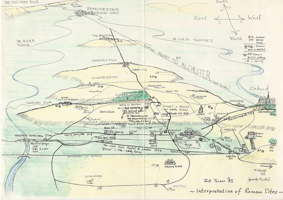
Map by Jack Turner showing Roman aspects of Wheatley which also identifies the Charlgrove (his spelling) or Chalgrove pit at the west end of Westfield.
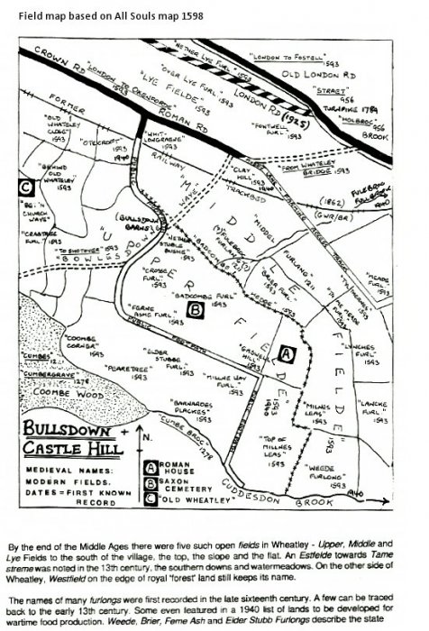
Field map based on All Souls map 1593.
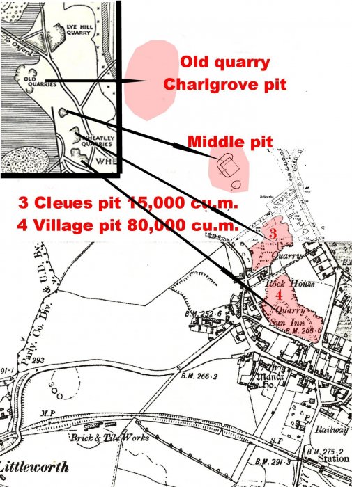
Map and pdf 'Wheatley limestone quarries' by Michael Heaton showing this and other pits on an OS map (with geological map inset). See also record 677
Map Addresses:
Related Items:
- Wheatley limestone
- Stone Pit and Lock-Up
- Bricks
- Mary Andrews' will
- Ann Bentlee's property
- Abraham Archdale's will, 1631
- Richard Archdale's will 1577
- Thomas Dormer's will, 1543
- Inventlory of Elin House's property, 1592
- George Martin's will, 1614
- Sibble Moore's will and inventory
- John Mount's will and inventory 1556
- Thomas Mount's will and inventory
- Thomas Mount of Wheatley, will and inventory
- Mary Russel's will, 1705
- Inventory of Marie Spencer's property, 1621
- Will of Thomas Temple, 1691
- Elizabeth Temple's will, 1698
- William Smart's will and property, 1670
- Thomas Whorwood III's will, 1736
- Edmund Whorwood's will 1735
- Jane Whorwood's will, 1715
- Thomas Whorwood II's will 1706
- Other wills
- Poor quality photos of Inns
- Oxfordshire Licensed Victuallers 1822
- Licensees 1684-1911
- Wheatley's roads
- Road maps
- A40 from Oxford to Wheatley
- 19th century coaching
- Account of highwaymen
- Shotover Hill and Turnpike
- Wheatley Bridge and ford
- 1930 roadworks
- Wheatley By-pass
- Meals On Wheels in Wheatley
- The Great Blizzard 1962
- History unfolded at Wheatley (1970)
- Families fear lives at risk
- Wheatley Society Exhibition, 1978, of clothes c.1900
- Wheatley Parish Council Elections 1979
- Newspaper cutting of A40 flyover
- Bypass newspaper account
- News reports and photo relating to A40 and M40
- Submission to public inquiry re M40
- Repairs to A40
- News reports regarding main roads
- Ground plans, M40 Wheatley services + recruiting
- Photos of newly-opened Wheatley services, 1998
- Demands for 20mph limit on Wheatley roads
- Milestones and Drove Roads in Oxfordshire
- Wheat Aid - 1991
- Wheatley Parish Council Elections 1983
- Wheatley Parish Council Elections 1987
- Wheat Aid 1991
- Morris tunes and songs
- Wheat Aid 1991
- Pharmacy opens in Wheatley 1993
- Roman & Saxon Wheatley 1984
- Rabbit Warren
- Revival of Wheatley Morris Dancers
- Origins of the Archive Room 2002
- Wheatley Post Office 2003
- Plastow's Travel 2003
- Handlist of Plans for Railways in Oxfordshire
- Directories of occupations
- Bennett's Business Directory 1904
- Bobbin making for trawlers
- Holton Stone Pit
- Ochre in Wheatley
- Brickmaking
- Horse-drawn harvesting machine
- List of schools from 1818
- Schools Old and New with list of heads
- Modern Citizenship
- A Trip to visit 'The Bremen' 1938
- Lark Rise to Lark Rise
- Wheatley Records 956-1956
- One More Millennium: Story of Wheatley and Holton
- Centenary of The Merry Bells 1888 -1988
- Holton, Wheatley and Oxford in the Civil War
- Around Wheatley
- Margaret Axford booklet on Tales from the Village Folk
- Wheatley Celebrates 1977
- Tanning Barn to Church
- 3 'R's by Candle light
- Sale notice for arable land at Wheatley
- Aerial photograph of Wheatley
- Panorame of Wheatley and photo of Wheatley High St, C 1930
- Sepia photo looking west up Wheatley High St
- 'Picture of Wheatley, Oxfordshire'
- Panoramic view of Wheatley, c. 1920
- Church Road / London Road link
- Blenheim, Kiln Lane & Westfield Roads
- View of Blenheim from Parish Plan 2004
- Farm Close Road and Beech Road
- Farm Close Road
- Ladder Hill
- Wheatley from Ladder Hill
- Mill View Garden centre entrance in 1988
- Map of Wheatley and Holton hospital
- East end of London Road in 1987
- London Road views from Wheatley bridge 1987
- London Road - Wheatley Bridge
- London Road photos 1979 - WVA only
- London Road 2004
- London Road from the Plough in 1987
- Wheatley Brook
- Old London Road
- Oxford to London road reconstruction
- Milestone in London Road
- London Road Kings Arms Turn
- London Road and Holton Park wall
- London Road from Holloway Road junction 1987
- London Road / Holloway - 1976
- London Road / Holloway circa 1930
- The Queen in Wheatley
- Views from Farm Close Lane in 1989
- North view from Farm Close Lane in 1975
- Steam Roller at the Holton Fair in 1970
- Farming - Wilfrid Sheldon's recollections
- Footpath Crown Road to Ambrose Rise 2004
- Wheatley's connection to Cuddesdon
- Memorial to Rev. Purson who died in 1903
- Articles of inquiry from 1759
- Jacket P1/A1a
- Skirt P1/A1b
- Dress P1/A2
- Dress P1/A3
- Skirt P1/A4
- Jacket P1/A5
- Skirt P1/A6
- Skirt P1/A7
- Navy flannel skirt P1/A8
- Black textured skirt P1/A9
- Gold lace blouse P1/A10
- Cream skirt P1/A12
- Pink underskirt P1/A13
- Skirt petticoat P1/A14
- Knickers P1/A15
- Stockings P1/A16
- Stockings P1/A17
- Mittens P1/A18
- Collar / brooch P1/A19
- Headcovering P1/A20
- Underskirt P1/A21
- Underskirt P1/A22
- Blouse P1/A11
- Aprons P1/A23 a,b,c,d
- Apron P1/A24
- Pinafore P1/A25
- Nightdress P1/A26
- Bonnet P1/A27
- Nurse's uniform P1/A28
- Nightgown P1/A29
- Coat and bonnet P1/A30 a & b
- Valance P1/A31 a,b,c
- Cushion cover P1/A32
- Nightdress case P1/A33
- Tray Cloth P1/A34
- Fur muff P1/A35
- Lace P1/A36
- 1-17 Bell Lane
- Notice re polluting of stream
- Extracts from Rev. Elton's diaries
- St Birinus Pilgrimage
- Edward Elton's appointment in 1849 and diary extracts
- Phoenix Assurance Firemark
- High Street - Traffic Calming
- New housing developments in Wheatley 1929-1987
- 1892 Royal commision on Labour ref Wheatley
- High Street, The London to Oxford Road
- Littleworth hamlet per Victoria County History
- Jane Whorwood
- Cromwell Cup
- High Street residents 1900 - WVA only
- Wheatley Military Hospital
- Forest Hill with Shotover book 1933 - WVA only
- Floods around Wheatley in 1992
- Road Names
- Wheatley area Churches
- Wheatley tortoises for Trinity College
- Notice found on URC wall
- Cuddesdon College centenary 1854-1954
- Littleworth and the windmill
- Collection of funeral and other cards
- Request for home nursing sheet
- Sheets of school work - WVA only
- Harris family letter - WVA only
- Harris family letter - WVA only
- Harris family letter - WVA only
- Harris family letter - WVA only
- Harris family letter - WVA only
- Harris family letter - WVA only
- Harris family letter - WVA only
- Harris family letter - WVA only
- Harris family letter - WVA only
- Harris family letter - WVA only
- Harris family letter - WVA only
- Harris family letter - WVA only
- Harris family letter - WVA only
- Harris family letter - WVA only
- Harris family letter - WVA only
- Harris family letter - WVA only
- Harris family letter - WVA only
- Harris family letter - WVA only
- Harris family letter - WVA only
- Harris family letter - WVA only
- Original Invoice from Harris Stores - WVA only
- Notes on property not relevant to Wheatley - WVA only
- A W Gamage Invoice - WVA only
- Various invoices - WVA only
- Invoice
- Solicitor's correspondence
- Post Office Telegram - original
- Letters written by Gilbert
- Letter written by Henry Harris
- Receipts of rental payments
- Letters from British Drug Houses 1917 - WVA only
- Order from British Drug Houses - WVA only
- Letters from British Drug Houses Ltd 1918 - WVA only
- The Kingerlee Institute
- Letter from Borough of Chipping Norton
- National League of Young Liberals
- South Oxfordshire Liberal Association
- Thank you letter to Mrs Harris 1926 - WVA only
- Letters from Bateman 1927 - WVA only
- Letters to Mr Harris - WVA only
- Housing developments in the twentieth century
- Aerial photographs of Wheatley and Holton
- Aerial photograph May 1961
- Aerial photograph of centre of Wheatley 1961
- Aerial photograph Coombe Wood and surrounding 1981
- Aerial photograph Castle Hill Farm and Roman Road 1981
- Aerial photograph Cuddesdon Road junction
- 11 Aerial photographs taken in 1994
- 4-5 mile walk around Wheatley described
- General views of Wheatley 2002 and 2018
- Postcard with five views of Wheatley
- Post card with five views of Wheatley
- Booklet of eight views of Wheatley c.1950
- Wheatley in the mid 70's
- Aerial view of Wheatley in 1952
- Saxon Graves on Castle Hill
- The Hinton Collection of early postcards of Wheatley - 1913-1915
- Winter snow 1991
- Firemark
- Stone hot water bottle
- 2 horse shoes
- Spar cutting hooks
- Stone water bottle
- Hook and bolt
- Thatching shears
- Stone water bottle
- Stone water bottle with cork
- Ostermilk tin
- Pattens
- Bit piece
- Sample of Ironstone
- Alleyway between Westfield Road and Park Hill
- Snow scenes January 1982
- Vaccination Register
- Fred Anson's Memorial Service
- Ministers who served in Cuddesdon & Wheatley
- The Changing Face of Wheatley
- WW1 swagger stick
- Four aerial views of Wheatley in 2007
- Litter Blitz 2004
- Letter from Brigadier General Alfred Douglas Miller
- Holton Church
- Military Hospital at Holton Park
- Holton Park Military Hospital
- Military Hospital
- Hammerstone
- Wheatley Flood 2008
- Edward Elton's appointment
- Footpath from Station Road to Farm Close Road
- Milk Delivery in Wheatley
- Local Views 1965
- Mary Sturch's collection of clothing c.1880-1917
- The Idler: a paper published at The Old Crown
- Meet of South Oxfordshire Hunt 1965
- Fifteen coins dating from 1771- 1873
- Oxford Journal 1760 - 1850
- Cattle bell
- Child's walking cane
- Cow bell
- 'The King's Smuggler' by John Fox
- Postcard of Wheatley taken from The Howe 1907
- Houses for Sale Summer 2010
- Sword found on Shotover
- Wartime account of Canadian allies running amok
- Wheatley Friendly Societies 1825 -1862
- Wheatley Charities
- Ironwork from the forge
- Traffic in the High Street July 2011
- Clay tiles
- Accounts of Village Organisations 1891
- Information about sale of Manor Farm 21/02/1846
- Cornfield Bakery
- A40 road noise
- Wheatley Park School 'failing'
- 'Rare bumblebee'
- Murder of Debbie Smith 2008
- Roland Yeates drugs dealer
- Jon Shirley
- SODC wants Wheatley to be removed from Green Belt
- Local History competition 1980
- O.S. maps (edition 1921)
- O.S. maps (edition 1974)
- Map of Wheatley district 'fieldnames'
- Two maps of Wheatley area 1980
- OS maps 1: 2500 Pathfinder Series 1980
- OS map 1880
- 4 copies of 1921 O.S. MAPS 1:2500
- O.S map Oxfordshire XXXIV SW ( 6 in. mile) 1938
- Christening gown
- Evening dress and accessories
- Wheatley District Conservative Assn
- Village Produce Association
- O.S. MAPS Wheatley area c.1960
- Road Map c. 1948
- O.S. MAP 1881
- O.S. Maps, 1921/22 1:2500
- O.S. Maps 1938 1:2500
- Black Lace Collar
- Horspath Reservoir
- Oxford Brookes University
- Mr Huxter's carriage in High Street
- Heritage trail around Wheatley by Pullen 1939-1955
- Historical Wheatley Map based on map from 1590s
- Home Guard
- OS map revised 1897-8
- Unexploded bomb in Wheatley
- Wheatley - a Snapshot of 3 centuries - Feb 2013
- Extracts from Directories up to 1939
- Iron Fire Surround (part), clay pipes & fossils
- Wheatley Bridge Farm
- Photos of Wash House - Wheatley Bridge Farm
- Community Education Wheatley - Oxford
- Report of mock election in 1974 at Wheatley School
- OS maps SP5805-5905 and 6005-6105
- Sales Poster
- List of Wheatley Men who served 1914-1918
- Shards of pots, tiles and debris associated
- Photo from Littleworth Flats to Acremead
- Origin of May Day chairs
- Aerial views of Wheatley 2007
- Enemy Air Attacks
- Rose Robinson memories
- The Servant Queen
- High Street Improvement Advisory Group
- Community Education Wheatley - Oxford Programme
- Service sheet to Welcome Bishop of Oxford
- Shops and Businesses in Wheatley before 1970s
- Receipt from Mobbs
- Book re: Rev. S.J.S. Groves testimonial
- Article on Plastows Coaches
- 1910 finance act - land holdings of 1 acre or more
- 1910 Finance Act District Valuation map & schedule
- Jack Turner's Wheatley Ochre
- Jack Turner's Historical Map of Wheatley - 1593
- Tin Helmet
- All Souls land ownership from 1593
- Traffic warning 1974
- Bell Lane traffic regilations 1966-1986
- Verse written by Rev Sturgess 'The Wheatley Bazaar'
- Oxfordshire Brickmakers
- Excerpt from 1956 'Wheatley the Village without a Green'
- The Wheatley Notice 19/8/1925
- Timetable of Old Berkeley Stage Coach
- Coaching routes
- Postcards by Churchley
- Postcard composite by Edward Hess
- Postcards by Worthington
- List of pub licensees from 1684-1966
- Ridge and Furrow
- Wheatley Brook
- Wheatley Enclosure Act
- Wheatley Enclosure Award
- Wheatley Primary School from 1811 to 2018
- Map of Turnpike roads in and around Wheatley
- Poors Allotments
- 1955, Ald Tombs - Wheatley and formation of Parish Council in 1932
- Littleworth postcard 1930s
- Harvest recollections by Wilfrid Sheldon
- 1944, 1950, 1954,1969 (2 versions) Aerial maps
- Silver penny of Athelraed 'Unraed' 975-1016
- Bridal Gowns
- Floods in 2008
- Extract from Wheatley Records
- Parish Plan 2004
- Wheatley Church of England School. Head-teachers and vicars 1891 to date
- Mark Bannister talk to Wheatley Society 2014
- Field names
- Wheatley Military Hospital
- John Fox book on Civil War
- 1797 map
- Vestry Minute book extracts 1829 to 1835
- Wheatley Designated areas
- OS Map 1939
- Notes from W H Tombs scrap book inc formation of Parish Council 1932
- Town meadow in 1910
- Holton - a small village in Oxfordshire 2019
- Wheatley marriages, baptisms and burials
- A Short History of Wheatley Stone
- Extract from ‘The Hassall family’ chapter in Wheatley Manor book
- Carpet beater
- Old lock and key
- School ink jar
- Saddler's clamp
- Air Raid Warden's whistle
- Civil Defence button 'CD'
- Leaflet about the rationing of clothing in 1941
- Clay moulds
- George III Cartwheel Penny
- 1872 map
- Parish Council 1977
- Wild and Wayward Folk of Wheatley
- Storm in June 1910
- Report in Oxford Mail 11 November 1946
- Oxford Times 3 June 1960
- Oxford Times article from 1980 about Wheatley
- Anthony Eden hat
- Oddfellows sash
- John Fox papers
- Parish boundary change in 2014
- Parish boundary changes cumulative to 2014
- Reformation in the Villages by John Fox
- Wheatley Heritage Trail
- Wheatley Heritage Trail leaflet
- Ann Rhymes study of Wheatley 1976
- Census information 1851 to 1911
- 'Commonwealth' half-groat found in Wheatley
- Artist's representation from the Cary map of 1820
- Tom Hassall memories
- October 1940 Bombs dropped on Wheatley
- Temperance movement
- Rev. William Hawkes Langley
- Riots in Wheatley October 1849
- Manorial or Feudal system
- An Historical Atlas of Oxfordshire
- Historical notes from Virginia Bainbridge
- Wheatley 2003
- Civil War history text used in Bygone Wheatley
- Coaching days on the Oxford Road
- National Archives listing of Wheatley Village Archive
- Bull-baiting in the 1830s
- Kellys Directory 1899 extract
- Panorama of Wheatley in 2019
- 1900 walk around Wheatley
- Reflections of the Covid 19 (Coronavirus) shut down in 2020
- Stanley map 1811
- Wilfrid Sheldon's memories
- Highway into Yesterday
- Set of 20 Frank Packer postcards from 1927
- Wheatley Walkabouts published by the Wheatley Society
- Wheatley Home Guard
- Holton Steam Rally Programme 1986
- Gardners Directory 1852
- Wheatley Urban District Council
- An Historical Atlas of Oxfordshire
- The Poor Law 1600-1834
- Poor Rate survey and valuation 1845
- The Most Difficult Village
- Testimonial to Morland House surgery February 2021
- Footpaths in Wheatley
- Pay List of the Cuddesdon Company of Volunteers 1803
- Storage boxes for clothes in the Archive
- Snow in Wheatley
- Keep-fit class c. 1970
- Datestones or date records found on or in buildings
- Wheatley in 1911
- Press article 1993 re development of Kelham Hall Drive
- Wheatley Productions list in date order
- A Country fit for Heroes to live in
- Wheatley Hospitality
- Keep Calm and Carry On
- Reginald Stamp, Queen’s Own Oxfordshire Hussars
- Wheatley painting looking north from the Howe by Bernard Hickey
- The lifting of lock-down in May 2021
- Wheatley Village Archive runner-in 2020 OPT awards
- Bert Barrett's memories from 1980
- An evening at the New Club in 2005
- Memories of Yvonne Florescu.
- The Oxford Times drops in on Wheatley in 1960
- Wheatley Common and riots
- Hundred Court Rolls
- Infant welfare clinic
- Postcard view of Wheatley c.1910
- Preparing two large photos for wall hanging outside the archive room
- Brasenose College Holdings summary
- Large pictures from the 1920s set of postcards
- Betty Brown's Spring
- Wheatley Village Study
- Collector of the General District Rate
- Houses in High Street, Wheatley
- Roman and Saxon Wheatley
- Edited collection of reminiscences from c. 1900
- Reminiscences of Miss Ellen Gunn for Mrs Leyshon
- Reminiscences from Mrs Hanson letters 1904-1906
- 3 'R's by Candle light
- Sheldon family notes and reminiscences
- Notes on her youth written by Miss Ellen Gunn
- Some facts about Wheatley
- Wheatley 50 years ago
- History of schooling in Wheatley
- Wheatley folk talking in 1985
- Shops and shopping post 1961
- Surnames found in family boxes
- Smocks
- Village Imformation for East Oxfordshire c. 1970
- Books on shelves
- Other recollections and a photo of Christine Jackson
- Poll books
- Clothes c.1900 exhibited by Wheatley Society Nov. 1978
- 1921 Wheatley census
- Auction announcement re sale of Coombe Wood
- Press cuttings 1936 and 1936
- Press article 2 April 1971 re Wheatley in the mid 19th century
- Assorted press cuttings from 1980 to 1982
- Assorted press cuttings from the 1980s
- Assorted press cuttings from the 1990s
- Assorted press cuttings from the 2000s
- Assorted press cuttings from the 2010s
- Wheatley 1950s walk
- Wheatley's sanitation problems in 1897 and 1900
- OS Map 1960
- Original newsprint articles on Wheatley A3 Folder
- Bryony & Nielsen project in 1988/9 on The Developmnt of Communications in Wheatley
- Parish Affairs file
- Sercombe family
- Various original pen and ink sketches
- New records added in February 2022
- Wheatley 1890-1910
- Primrose League
- Wheatley baptisms 1851-1963
- Wheatley burials 1813-1985
- Oxford History Centre collection of Wheatley images
- Fred Anson's school log book 1950-1972
- Frank Smith postcards
- Country series postcards
- TVAP Series XXX1 postcards
- Coloured 'Greetings from Wheatley' postcard
- Postcards scanned and catalogued from David & Leslie Hurdley collection
- The Racks
- Cut marks, bench marks, trig points etc
- A View Rich in History
- Parish Councillors 2003-2007
- History of Wheatley Parish Council
- 'Blown' brick resulting from the addition of lime
- Brick made in the Cooper brickyard
- Tiles found on the Roman Villa site
- Large, possibly oxen, bones
- London Brick Company brick
- Oxford 1902 Coronation medal
- VPA Wine Circle
- Fossil of late Jurassic bivalve found near Old Road Wheatley
- Clay pipe bowl
- Illuminated display of local artefacts
- Toogood certificates awarded to William Tombs
- Turner's Royal window to commemorate the passing of Queen Elizabeth II
- WW2 records in WVA
- Comrades of the Great War
- Robbins pocket books
- Census card information by family name
- Keely Construction
- Listed Buildings in Wheatley
- Wheatley limestone history
- Wheatley brickworks history
- Builders in Wheatley
- Wheatley pub history
- Wheatley tanning history
- Avery sawmill history
- Wheatley ochre history
- Wheatley population history
- Wheatley World War 2 history
- 1921 census
- Political unrest
- District Nurse Summers
- 2023 - A Hundred Years Ago in 1923
- Women's Working-Room Fund 1895
- Owner occupation in 1910
- Land Tax assessments 1785-1802 and Enclosure Award 1813
- Wheatley Army Cadets in the mid-1950s
- Wheatley Society bulletin and other cover designs
- Traffic survey 2013
- House replacments in the period 1900-1960
- Wheatley population 1961-1974 and housing developments
- Post Office letter-box decorated by the W.I.
- Oxfordshire History Centre. Details of records for Wheatley
- Population and dwellings 1921-1974
- Book on Wheatley compiled by Rose Robinson
- hwaetleah
- Coach through Wheatley in May 1929
- Westbrooke's Charity and Town Meadow Charity
- OS map 2024
- High Street and Church Road shops then and now
- Historic England images from the 1950s.
- Wheatley Village Archive articles in the Parish Newsletter
- Wheatley-on-Sea
- Archive stock in Merry Bells cupboard
Archive Number: